|
||||||
|
Enjoy This Site?
Then why not use the button below, to add us to your social networking site or your favorite bookmarking service? |
Bolivia Climate & WeatherBolivia Facts Main Page Currency Destinations Holidays Flag Pictures Wildlife Although Bolivia lies near the equator, the Bolivia climate and weather varies greatly from region to region. The weather in Bolivia is strongly influenced by the extreme differences in altitude and the amount of rainfall a specific region receives, gives the country a variety of climates. There are basically two seasons in Bolivia, summer and winter. Bolivia lies in the southern hemisphere, therefore the seasons are opposite compared to the northern hemisphere. The summer months in Bolivia are from November through March. In the summer it usually sees the most amount of rainfall and is warmer. The winter months are from April through October and are typically cooler and drier. Bolivia can be visited year round, with the best season for adventure travel is the dry, cooler season from April through October. This is the best time for hiking and trekking the Inca Trails through the Andean Mountains and for Amazon Rainforest explorations. Expect some rain if traveling between November through March. The climate of Bolivia can be identified as having five different climatic and geographical regions:
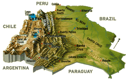
Altiplano Region - High AndesAltiplano Region has the highest elevation in all of Bolivia and is in Andean Mountain range. This region is located in in the western portion of Bolivia and runs through La Paz, Lake Titicaca, Oruro, Salar de Uyuni and into parts of Peru.The Altiplano Region typically has a chilly climate and is considered to have a semi-arid climate. Since it is at a high altitude the thin air retains little heat and the air is typically dry, with cool temperatures and strong cold winds that can sweep over the region. Temperatures year round are cool to mild, the average in summer being 72°F (22°C) and in winter 59°F (15°C). During the night temperatures can get to the freezing levels. The rainy season is in the summer months between November to March. The winter months of April to October tends to be dry, cool, and sunny. Snowfall events may happen in the winter months, but it is not very common (1-5 events per year). Although the region can be visited year round, April to October is a great time to go, since it will have the cool, crisp, clear days. The summer wet season from November to March will be a bit warmer but rain can fall on most days and low clouds hover over the region. No matter when you go, always be prepared for wind and cold nights. Also, remember the Altiplano region is high, you'll be in altitudes ranging from 4,500 meters (15,000ft) to 3100 meters (10,170 feet). So, Be prepared to feel the altitude.Follow these High altitude travel tips. Cordillera Central - Highland ValleysJust east of the Altiplano region lies the central highland valleys. The main cities that lie in this region are Cochabamba, Sucre, Tarija, and Potosi. Most of this region is considered to have Bolivia's most comfortable climate, with sunny warm days and cool nights.This region is part of the Cordillera Central mountain range, which is the central of three ranges of the Andes and has the second highest peaks after the Altiplano region. The region consists of small mountains, rolling hills, valleys and fertile basins. Here the land is fertile and covered in lush green forest. Temperatures are very pleasant during the day, usually between 17-27ºC (62-80ºF), with cool nights. Since the region is not as high as the the Altiplano region, the weather has a Mediterranean-like climate year round. Although, Potosi will have a much colder climate due to its altitude of 13,454 feet (4090 meters) above sea level. Summer in the central highland valley region sees the most amount of rainfall and winter is considered the dry season. The region does sit at an altitude where one would think it would snow, since Bolivia lies near the equator it doesn't snow there. However, Potosi is the only area that does see a little snow due to its high altitude. Yungas ValleyThe Yungas Valley occupies the eastern slopes of the Andean Mountain range and the region has an elevation that ranges from 1,000 meters to 3,500 meters (3,300 feet to 11,500 feet).The climate of the Yungas is considered to have a tropical to sub-tropical climate. Here it is warm, humid and rainy year round, with most amount of rainfall occurring in the summer between November to March. Rainfall can total up to 155 centimeters annually. (61 inches) Clouds coming from the higher Altiplano region collide with the warmer air from the Amazon basin, depositing large amounts of rainfall year round. Making the steep, rugged terrain of the Yungas covered in lush vegetation and swift rivers running through the deep valleys. Although the region is relatively remote, it does produce coca, coffee, tobacco, sugar, and tropical fruits. Since it rains almost year round, the best time to go to the region is the more predictable drier season from April to October. One of the few ways of getting to the Yungas Valley is taking the Yungas road or known as the world's most dangerous road. Eastern LowlandsThe eastern lowlands of Bolivia covers about half of Bolivia and includes anything that is north and east of the Bolivian Andes. The region runs through Santa Cruz, Trinidad, Beni, and up through Pando.To the north and northeast of the Bolivian Andes lies the Amazon basin around the Beni and Pando regions. The climate here is wet and tropical, with high humidity, and heavy rainfall. The northeast trade winds, blows across the Amazon Basin, brings plenty of rainfall and flooding often occurs in the region. Daytime highs can average more than 30° C most of the year. Moving farther south, to the east central part of Bolivia around the Santa Cruz department, the climate here is sub-tropical to tropical. In the summer from October through April, northeast trade winds from the Amazon area predominate, and the weather is hot, humid, and rainy. In the winter from May through September, the weather is a little more comfortable and drier. The southeast trade winds take control in the winter bringing in cooler air and sometimes strong winds blowing in from the Argentine pampas, called surazos, can reach this region during winter and can bring even cooler temperatures for several days. Gran ChacoThe Gran Chaco is located in the south to southeastern section of Bolivia and also runs through Paraguay, Argentina and a portion of Brazil. The land is a sparsely populated and lies in a lowland region with flat scrublands and grasslands. Notable Bolivian cities in this region are Villamontes and Camiri.The climate of the Gran Chaco is semi-arid to semi-tropical. The northeast trade winds bring rain and hot humid conditions only during summer from December-March. The winter months are dry with hot days and nights may get frost. Annual rainfall ranges from 500-900mm. Median temperatures vary from 23°C-28°C (73°F-83°F) and is known to be the hottest in all of Bolivia, with low humidity the dry heat it can reach extreme temperatures up to 46ºC (115ºF) or even below freezing at night in some areas. Other Related Pages:
|
|||||