Travel-Bolivia logo

Enjoy This Site?
Then why not use the button below, to add us to your social networking site or your favorite bookmarking service?
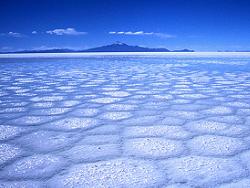
Salar de Uyuni

Salar de Uyuni - Salt Desert Uyuni, Bolivia - South America Salt Flats - Salar de Uyuni Bolivia - South America


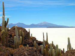
Salar de Uyuni is the world's largest and highest salt desert in the world sitting at an altitude of 3,650 meters (11,975 feet) above sea level. To get there one must travel to a small town called Uyuni in southwest Bolivia, which is near the border of Chile.

Uyuni is the starting point to see this amazing salt desert that covers 4,200 square miles (11,000 square km). Which is about 25 times bigger than the Salt Flats in Utah.

It is believed that about 25,000 years ago, the area was part of a giant prehistoric called Lake Minchin and that the lake covered much of southwest Bolivia. Eventually, the lake dried up and left behind a huge salt desert known as Salar de Uyuni.

The Salar is said to be formed when the last waters from the lake evaporated, leaving behind salt that eventually deposited into the lowest lying part in that region and being leached by rain from the surrounding mountains.

Today, Salar de Uyuni is a popular tourist attraction where you can even find a hotel made of salt. Driving across Salar de Uyuni is one of the most fascinating experiences in South America. While taking a trip through this region and across this salt desert you encounter some of the most amazing natural wonders in the world.

You'll see sights that seem like from another planet. Sights of unusual rock formations, red mountains, geysers, hot springs, volcanoes, giant cacti, red and green lakes. You'll also find wildlife such as many flamingos, llamas, vicuña (llama relative), and strange looking rabbits.

A trip to this remote corner of Bolivia would not be complete without continuing to see two of Bolivia's natural wonders, the fiery red Laguna Colorada and the the greenish-blue colored Laguna Verde. These spectacular lakes lie about 350km (215 miles) southwest of Uyuni, across a desert landscape and over rugged dirt tracks.


Most Interesting Sights

Laguna VerdeLaguna Verde (Green Lagoon) is a beautiful green colored salt lake on the Chilean border at the foot of volcano Licancabur. Its color is bright green due to arsenic content.


Laguna Colorado - Uyuni Bolivia, South AmericaLaguna Colorada (Red Lagoon) is a red colored salt lake, caused by red sediments and pigmentation of algae. The lake is home to many flamingos.


Salar de Uyuni Fish IslandIsla del Pescado (Fish Island) is an oasis in the middle of Salar de Uyuni, with a unique and isolated ecosystem that is populated by cacti, some of which are up to 30 feet tall (about 10 meters) and more than a thousand years old. Called fish island because the island looks like a huge fish from far away.

arboles-de-piedra- Bolivia - Chile - South AmericaArboles de Piedra (trees of stone) is an unusal rockformation that looks like a tree. Geologists are baffled by this formation, see if you can figure out how this strange formation took shape. It is fun to explore and photograph.


Mount Illimani - La Paz, BoliviaNevado Sajama Volcano
Nevado Sajama is an extinct volcano and the highest peak in Bolivia with an elevation of 6,542 m (21,463 ft). The mountain is located in Sajama National Park in the southwest area of Bolivia near the border of Chile.

  • Laguna Polques contains many natural hot springs where visitors can come and take a dip and warm up.
  • Sol de Manana is the geothermic area where, you can see geysers and many boiling mud pools on the surface. Some holes constantly spout muddy water to a height of about 10 feet.
  • El Valle de Dali has a landscape that shows all the colors of the rainbow. An excellent place for pictures and to spot wildlife.

  • Weather

    Since Salar de Uyuni is basically a desert, the weather conditions in the region can get extreme, from hot fierce sun during the day and to freezing night temperatures.

    Temperatures in the Uyuni region typically average 20°C (68°F) for highs during the day, but during the night it can dip well below freezing and the wind chill can add to the cold. Also, it is not uncommon for temperatures in the Salar de Uyuni to reach 30°C (86°F) during the day and fall to -25°C (-13°F) the following night.

    November through March is summer and warmer, but sees the most amount of rainfall and the salt flats will typically be covered in shallow water.

    As far as weather, the best months to visit Uyuni are between June and October, after the worst of the winter chills and before the summer rains. At any time of year you'll need protection against sun, wind and cold.


    Things to Bring

    Uyuni sits at an altitude of about 12,000 feet (3,650 meters.) You should bring warm clothing no matter what time of year you go because of the altitude. Also, the route to Uyuni is cold, some buses going there may not have very good heat. The salt flats have high solar radiation due to its altitude and the air is dry. It is good idea to bring extra water. Here is a list of recommended things that would be a good idea to bring:

  • Warm clothes and wool socks
  • Hat and gloves
  • Sleeping bag
  • Swimming suit and towel
  • Sun block and sun glasses
  • lotion and lip moisturizer

  • Interesting Trivia

  • Salar de Uyuni is estimated to contain 10 billion tons of salt, which about 25,000 tons is extracted annually.

  • Salar de Uyuni is one of the flattest places on Earth. In 2002, a ground survey team, aided by global positioning systems (GPS), showed only small variations in elevation of less than a meter across the Salar de Uyuni, an area almost half the size of Wales.
  • Due to its large size, flatness, and high surface reflectivity when covered with shallow water, Salar de Uyuni makes an ideal target for the testing and calibration of remote sensing instruments on orbiting satellites used to study the Earth. Also providing an excellent target surface the skies above Salar de Uyuni are so clear, and the air so dry, that the surface works up to five times better for satellite calibration than using the surface of the ocean.


    Other Related Pages: