|
||||||
|
Enjoy This Site?
Then why not use the button below, to add us to your social networking site or your favorite bookmarking service? |
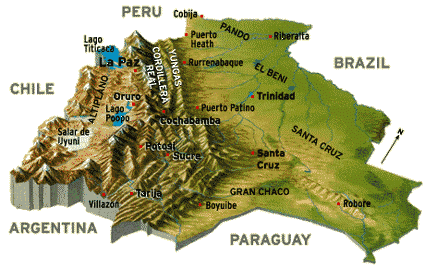
Bolivia GeographyBolivia Facts Main Page Currency Destinations Climate Flag Pictures Wildlife Bolivia Geography Much of Bolivia's appeal for travelers is the beautiful Bolivia geography, with its spectacular vistas and natural attractions. The geography of Bolivia is unique, with the Andean Mountain range at their widest in Bolivia and is one of two landlocked countries in South America. Bolivia once had a Pacific coastline until 1880 when it was lost to Chile in war. The unique features of Bolivia's geography include the Altiplano, a highland plateau of the Andes, Lake Titicaca and Salar de Uyuni, a massive salt desert. Bolivia is the fifth largest of the 13 South American countries in size and the eighth largest in population. Bolivia is about the same size as France and Spain combined in regards to land mass size. Bolivia is bordered by Chile and Peru to the west, Brazil to the north and east and Argentina and Paraguay to the south.
Altiplano Region - High AndesAltiplano Region has the highest elevation in all of Bolivia and is in Andean Mountain range. This region is located in in the western portion of Bolivia and runs through La Paz, Lake Titicaca, Oruro, Salar de Uyuni and into parts of Peru. The Altiplano region lies at an altitude of around 3,100-4,500m (10,170-15,000 ft) above sea level. There are many snow capped mountain peaks located in the Altiplano region, that reach an altitude between 5,000-6,500 meters.
Cordillera Central - Highland ValleysJust east of the Altiplano region lies the central highland valleys. The main cities that lie in this region are Cochabamba, Sucre, Tarija, and Potosi. Most of this region is considered to have Bolivia's most comfortable climate, with sunny warm days and cool nights. This region is part of the Cordillera Central mountain range, which is the central of three ranges of the Andes and has the second highest peaks after the Altiplano region. The region consists of small mountains, rolling hills, valleys and fertile basins.
Yungas ValleyThe Yungas Valley occupies the eastern slopes of the Andean Mountain range and the region has an elevation that ranges from 1,000 meters to 3,500 meters (3,300 feet to 11,500 feet). Check out the Yungas road or known as the world's most dangerous road. located in the Yungas Valley.
Eastern LowlandsThe eastern lowlands of Bolivia covers nearly half of Bolivia and includes anything that is north and east of the Bolivian Andes. The region runs through Santa Cruz, Trinidad, Beni, and up through Pando. To the north and northeast of the Bolivian Andes lies the Amazon basin around the Beni and Pando regions.
Gran ChacoThe Gran Chaco is located in the south to southeastern section of Bolivia and also runs through Paraguay, Argentina and a portion of Brazil. The land is a sparsely populated and lies in a lowland region with flat scrublands and grasslands. Notable Bolivian cities in this region are Villamontes and Camiri.
Geography of Bolivia FactsLocation: Geographic coordinates: Land Area: Land boundaries: Coastline: Climate: Terrain: Elevation extremes: Land use: Natural resources:
DepartmentsBolivia Map - Departments Bolivia is divided into nine departments (departamentos):
|
|||||